ENGINEERING SURVEY IN SAUDI ARABIA
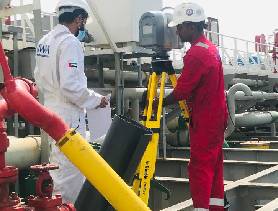
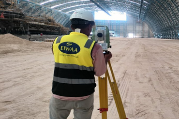
EIWAA Engineering Survey Services in Saudi Arabia offers Topographical Survey, Total Station Survey, 3D Scanning, LiDAR Scanning and BIM Modeling Services. In offshore and Marine Engineering Services, our retrofitting engineers and Surveyors provide installation assistance for Hull Air lubrication System, EGCS and Ballast water treatment system. CAD Drawings of 2D and 3D drawing are the outputs of Detailed Engineering solutions. LiDAR scanning of building can be utilized for interior designing, creating architectural Model, Reverse engineering etc. Total station Surveys and Surveying are used for Tank Dimensional Control, Tank Dimension Inspection, Alignment Survey, Asbuilt Model, Asbuilt drawing preparation etc.
ARCHITECTURAL ENGINEERING SURVEY
EIWAA Engineering Survey Services in Saudi Arabia provides Topographical Survey, Total Station Survey, 3D Scanning, LiDAR Scanning and Revit BIM Modeling Service. We are providing Engineering survey Services in Oil and Gas, Marine as well as Civil and Architectural Engineering Services. Our Architectural Engineering Services in Saudi Arabia provides 3D Laser Scanning and Detailed Engineering by Terrestrial Scanning, LiDAR Scanning Services ,3D Mapping, 3D Visualization and 3D Rendering Services. Supportive Services are 3D Imaging,3D Digital Survey Services and 3D Modeling Services etc. Our Building Scanning Services offers additional services of 3D Modeling Services, BIM Modeling, Revit Modeling, Architectural Rendering and Building Information Modeling etc. for architectural Buildings and Heritages. Building Information Service and Revit Modeling Service creates BIM Model, Scan to BIM Service, Clash detection BIM Documentation, BIM Documentation Models, Revit family etc. Our BIM Services in Saudi Arabia covers the scope of Architectural BIM Services, Structural BIM Services, Mechanical BIM Services, Scan to BIM Services and Revit Modeling Services.
MARINE ENGINEERING SURVEY
Our Marine Survey services in Saudi Arabia offer Topographical Survey, Total Station Survey, Laser Measurement Asbuilt Survey, Alignment Survey etc. For offshore structures. A lot of marine retrofitting solutions like MOPU to MODU conversion projects, hull air lubrication systems (ALS), exhaust gas scrubber systems (EGCS), and ballast water treatment systems (BWTS), are put into service using 3D scanning and Modeling Services. In order to convert and retrofit engineering of ships, ports, rigs; marine feasibility study is also necessary before 3D scanning and modeling service. We are providing Total station Survey and Laser Measurement Services for Storage Tank Dimensional Control, Tank Dimension Inspection, Alignment Survey, As built Model, As built drawing preparation in 2D and 3D Drawings etc.