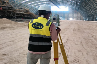
Topographical Survey

TOPOGRAPHICAL SURVEY SERVICES IN SAUDI ARABIA

TOPOGRAPHICAL SURVEY SERVICES IN SAUDI ARABIA

EIWAA Architectural Engineering Survey Services provides Topographical survey services in Saudi Arabia utilizing alignment surveys, as-built surveys and total station surveys to ensure precise measurements at construction and oil and gas projects. EIWAA Engineering Survey Services is the leading Topographical Survey Service in Saudi Arabia with Total Station Survey, 3D laser scanning and LiDAR Scanning. In marine, oil and gas and power plants, topographic survey services are necessary to confirm a site’s as-built conditions, position, height, and elevations etc. Architects and engineers employ topographic surveys in conjunction with boundary surveys to create accurate and appropriate designs that consider the existing conditions.

The scope of Topographical Survey services includes gathering data on all natural and man-made land features of buildings and heritages. As an architectural design firm in Saudi Arabia, we commit to providing BIM modeling services, AutoCAD drafting services, Revit MEP services, and structural BIM services. Being the leading topographic survey company in Saudi Arabia, we constantly offer additional services including LiDAR 3D mapping, Building Information Modeling, Revit modeling, 3D laser scanning, 3D imaging etc. We are one of the best engineering survey company in Saudi Arabia for performing land survey services, level surveys, and demarcation surveying services.

ENGINEERING ASBUILT SURVEY SERVICES

As the name implies, as-built survey services are performed on-site during a specific time frame. To facilitate understanding of the present situation, building asbuilt survey services offer quick and accurate floor plans and drawings. A skilled total station survey includes a total station to measure coordinates in remote areas to ascertain the tilt and alignment of marine and power plant equipment in its installed condition. Major Surveying Engineering Services in Saudi Arabia are Boundary Surveys, Stakeout surveys, Level surveys, Storage tank Settlement Surveys, Excavation and pipeline surveys etc. Topographical survey Services are always in relation to dimensional control by 3D Laser measurement Services for Storage tank Inspection, Fairground Inspection, Piping and Pipeline Inspection etc.

Storage Tank Terminals

Asbuilt survey reports of storage tank terminals include drawings, and structural diagrams for asbuilt documentation.

Architectural Building

Used for condition assessment of buildings and heritage by 3D Laser scanning by LiDAR Scanner and advanced total station

Power plants and Refineries

Asbuilt Survey to determine the structural integrity and condition assessment of piping and storage tanks

Oil and Gas Services

Pipeline survey and Topographical survey Services for asbuilt documentation and P&ID Diagram preparations.

LAND SURVEY IN SAUDI ARABIA

Land surveying services in Saudi Arabia involve the accurate measurement and mapping of land surfaces to determine the boundary line and other features of construction as well as infrastructure projects. By using Boundary Surveying services, EIWAA provides property line, boundary line and demarcation lines. Geodetic survey and Asbuilt survey services come under critical service categories of land survey where precise satellite technology and geodesy measure large area of land accurately.
EIWAA uses advanced total station, GPS/GNSS,3D Laser scanners and Drone services for measuring vast areas of land accurately and precisely. We are one of the best Topographical survey companies in NEOM by providing level survey, Alignment survey, Demarcation Surveys and Boundary Survey. As a professional Topographical survey company in Jeddah, we are providing construction survey Services by advanced total station and 3D Scanners.

UNDERGROUND UTILITY SURVEY AND UTILITY MAPPING SERVICES

We are one of the major Underground utility survey companies in Saudi Arabia by providing utility survey services and utility mapping in major power plants and refineries. Utility location survey by electromagnetic location, Ground penetrating radar(GPR Survey) and SONAR to identify and mark the locations. Underground utility Survey includes surveying and mapping of water, gas, electricity, sewage and telecommunication sources without any excavation works.
Underground Utility Survey Services in Saudi Arabia include utility location surveys, Subsurface utility engineering, Ground Penetrating Radar (GPR)Services, Utility Mapping Services and electromagnetic utility locating services.
Ground penetrating Radar Services also known as GPR Services in Saudi Arabia use GPR System to scan the subsurface for locating utility lines and structures without excavation works. Electromagnetic utility mapping Services are ideal for conductive materials of metallic pipes, cables and wires. Through utility mapping, EIWAA can provide detailed maps of locations, depth and underground utilities. Underground utility surveying and mapping services can reduce risks, compliance with regulatory requirements, data preservation and planning.

FREQUENTLY ASKED QUESTIONS

A drawing that indicates the precise boundaries of a property is called a land survey. In addition, a survey will specify the size and position of any buildings or other site enhancements on the land.

Being a Topographical Survey Company in Saudi Arabia, we are always pleased to offer every stage of the laser scan to BIM service, such as laser measurement, 3D modeling, LiDAR 3D scanning, and Revit Architecture Modeling. Our architectural design services in architecture engineering include topography services, 3D rendering services, as-built drawing services and 3D scanning services.

Power plants, refineries, and civil architectural buildings frequently use our third-party engineering surveying services of topographical surveying services, total station surveying services and as-built survey services.

Open chat
Hello 👋
Can we help you?